|
| |
|
|
|
|
Governments - Federal, State, County, City
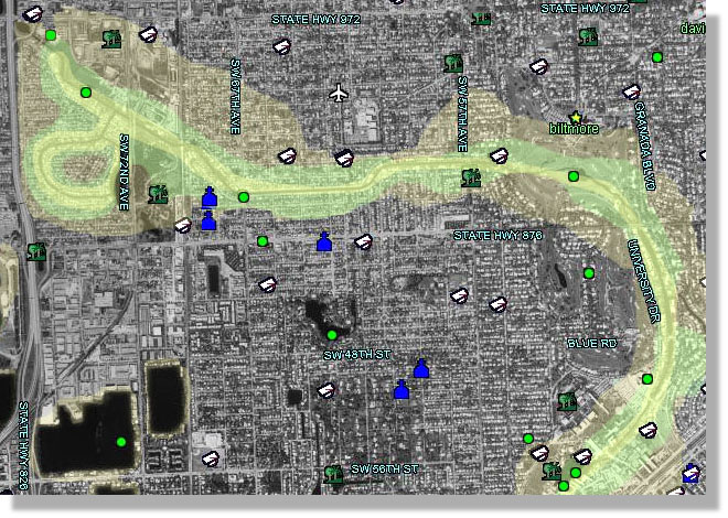
Governments at all levels need satellite and aerial images to make better decisions in the fields of land surveying, mapping, planning, and development. Most local governments have their own departments to analyze zoning, growth, and environmental issues. The data utilized by these GIS departments is not shared with other departments that could potentially utilize the same information. The expenses related to serving the data with existing GIS software makes its sharing prohibitive. TerraFly solves this problem by providing a cost-effective solution that enables enterprise-wide access to GIS data without the high overhead costs of GIS features and functionality. Further, the local area images can be made available for public use over the Internet and can be integrated with information provided by the local government. TerraFly can also be a great tool for governmental agencies working in the fields of environmental protection, forestry, natural resources conservation, National Parks, ecology, and similar areas. Instead of providing users with static satellite images only, TerraFly gives them the capability to fly over these images, making the survey achieve its objective far more efficiently. Here is an example of a flood zones application. USGS black&white aerial photography is overlaid with street names and public buildings, and then shaded in various intensities of yellow reflecting flood probabilities:
Please contact us to learn how TerraFly can increase the efficiency of your decision-making process, thereby saving you precious time and money. Request more information at . | ||
|
|
|
|
|
|
© Copyright 1997-2003, TerraFly.com. All rights reserved |